Aerial Photo of West Vancouver (Park Royal)
Description
- Creator
- Unknown photographer
- Media Type
- Image
- Item Type
- Photographs
- Description
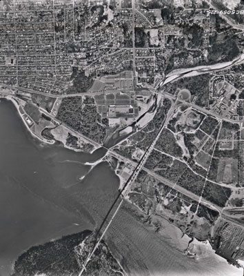
- An aerial photograph of West Vancouver in the Ambleside area. The image spans from Capilano Road to approximately 14th Street and North to Inglewood Avenue. Image taken after Park Royal South construction.
- Date of Original
- 1950s
- Subject(s)
- Local identifier
- 4533.WVML
- Language of Item
- English
- Geographic Coverage
-
-
British Columbia, Canada
Latitude: 49.32135 Longitude: -123.14015 -
British Columbia, Canada
Latitude: 49.31467 Longitude: -123.13921 -
Marine Drive
Latitude: 49.3387463 Longitude: -123.1975597
-
Park Royal South
Latitude: 49.3263142 Longitude: -123.138974
-
Inglewood Avenue
Latitude: 49.334523 Longitude: -123.1514709
-
- Copyright Statement
- © West Vancouver Memorial Library
Downloading images from this site is governed by our Guidelines for Appropriate Usage and Conditions of Use. - Reproduction Notes
- Scanned July 2013 using Epson Perfection V700 Photo at 300dpi and 100% of original image size. Alternate Versions: Lossless TIF from original scan at 300dpi and 100% of original print. W25.5 x H25.5 cm black & white print on photo paper.
- Contact
- West Vancouver Memorial LibraryEmail:turquhart@westvanlibrary.ca
Website:
Agency street/mail address:1950 Marine Drive
West Vancouver, BC V7V 1J8
604-925-7400