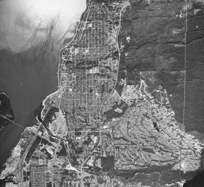
Aerial View of West Vancouver Shore
Description
- Creator
- Glenesk, Alf
- Media Type
- Image
- Item Type
- Photographs
- Description
- An aerial photograph of the West Vancouver shoreline towards Dundarave, Lions Gate Bridge, Stanley Park, and the Strait of Georgia.
- Date of Original
- June 1967
- Subject(s)
- Local identifier
- 2233.WVML
- Language of Item
- English
- Geographic Coverage
-
-
British Columbia, Canada
Latitude: 49.33296 Longitude: -123.18595 -
British Columbia, Canada
Latitude: 49.31467 Longitude: -123.13921 -
British Columbia, Canada
Latitude: 49.49965 Longitude: -124.00274
-
- Copyright Statement
- © West Vancouver Memorial Library
Downloading images from this site is governed by our Guidelines for Appropriate Usage and Conditions of Use. - Copyright Holder
- Glenesk, Alf
- Reproduction Notes
- Scanned January 2012 using Epson Perfection V700 Photo at 300dpi and 100% of original image size. Alternate Versions: Lossless TIF from original scan at 300dpi and 100% of original print. W25.5 x H25 cm black & white print on photo paper.
- Contact
- West Vancouver Memorial LibraryEmail:turquhart@westvanlibrary.ca
Website:
Agency street/mail address:1950 Marine Drive
West Vancouver, BC V7V 1J8
604-925-7400