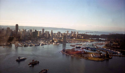
Aerial View of Vancouver Harbour & Deadman's Island
Description
- Creator
- Morgan, Ken
- Media Type
- Image
- Item Type
- Photographs
- Description
- Aerial view of Vancouver Harbour including Deadman's Island, Vancouver Yacht Club, Lost Lagoon, Downtown Vancouver, and Point Grey in the distance.
- Date of Original
- 1998
- Subject(s)
- Local identifier
- 4402.WVML
- Language of Item
- English
- Geographic Coverage
-
-
British Columbia, Canada
Latitude: 49.29502 Longitude: -123.12279 -
British Columbia, Canada
Latitude: 49.29569 Longitude: -123.14034 -
British Columbia, Canada
Latitude: 49.26635 Longitude: -123.26935 -
British Columbia, Canada
Latitude: 49.24966 Longitude: -123.11934
-
- Copyright Statement
- © West Vancouver Memorial Library
Downloading images from this site is governed by our Guidelines for Appropriate Usage and Conditions of Use. - Copyright Holder
- Ken Morgan
- Reproduction Notes
- Scanned July 2013 using Epson Perfection V700 Photo at 300dpi and 100% of original negative size. Alternate Versions: Lossless TIF from original scan at 300dpi and 100% of original negative.35mm colour gelatin emulsion negative.
- Contact
- West Vancouver Memorial LibraryEmail:turquhart@westvanlibrary.ca
Website:
Agency street/mail address:1950 Marine Drive
West Vancouver, BC V7V 1J8
604-925-7400