Aerial Photo Park Royal
Description
- Creator
- Aero Surveys Ltd.
- Media Type
- Image
- Item Type
- Photographs
- Description
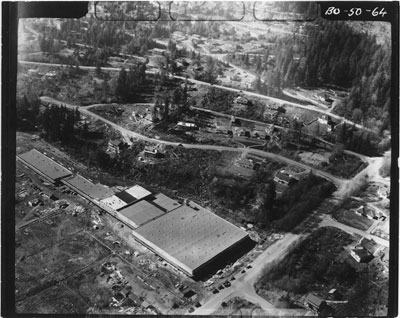
- Aerial photo of Park Royal and Sentinel Hill. Houses and streets can be seen above Park Royal.
- Date of Original
- May 1, 1950
- Subject(s)
- Local identifier
- 3370.PR
- Language of Item
- English
- Geographic Coverage
-
-
British Columbia, Canada
Latitude: 49.32683 Longitude: -123.13773 -
British Columbia, Canada
Latitude: 49.33576 Longitude: -123.14015 -
Taylor Way
Latitude: 49.3331239 Longitude: -123.1349119
-
- Copyright Statement
- © West Vancouver Memorial Library
Downloading images from this site is governed by our Guidelines for Appropriate Usage and Conditions of Use. - Copyright Holder
- Aero Surveys Ltd.
- Reproduction Notes
- Scanned July 2011 using Epson Perfection V700 Photo at 300dpi and 100% of original image size. Alternate Versions: Lossless TIF from original scan at 300dpi and 100% of original print. W13 x H11 cm black & white print on photo paper.
- Contact
- West Vancouver Memorial LibraryEmail:turquhart@westvanlibrary.ca
Website:
Agency street/mail address:1950 Marine Drive
West Vancouver, BC V7V 1J8
604-925-7400