Taylor Way
Description
- Creator
- Snarski, Jan
- Media Type
- Image
- Item Type
- Photographs
- Description
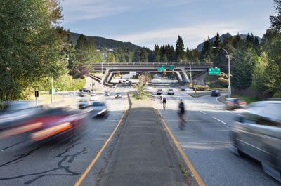
- View of Taylor Way, the Upper Levels Highway and the British Properties. Photographed August 27, 2012 for the District of West Vancouver Centennial Year. Geolocation: Lat: 49.326325 Long: -123.134862.
- Date of Original
- August 27, 2012
- Subject(s)
- Local identifier
- D0290.WVML
- Language of Item
- English
- Geographic Coverage
-
-
British Columbia, Canada
Latitude: 49.34966 Longitude: -123.13595 -
Taylor Way
Latitude: 49.3331239 Longitude: -123.1349119
-
Upper Levels Highway
Latitude: 49.3402994 Longitude: -123.1495761
-
- Copyright Statement
- © West Vancouver Memorial Library
Downloading images from this site is governed by our Guidelines for Appropriate Usage and Conditions of Use. - Copyright Holder
- West Vancouver Memorial Library
- Location of Original
- West Vancouver Memorial Library
- Reproduction Notes
- Taken August 2012 using a Canon EOS 5D MARK II. Alternate Versions: Lossless TIF colour digital file.
- Contact
- West Vancouver Memorial LibraryEmail:turquhart@westvanlibrary.ca
Website:
Agency street/mail address:1950 Marine Drive
West Vancouver, BC V7V 1J8
604-925-7400