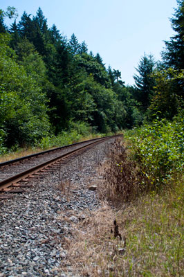
Railway at the end of the Seaview Walk
Description
- Creator
- Theilmann, Helen
- Media Type
- Image
- Item Type
- Photographs
- Description
- A view, looking East, of the railway located at the end of the Seaview Walk. The track is almost directly beneath the Horseshoe Bay exit of the Upper Levels Highway.
- Date of Original
- July 26, 2012
- Subject(s)
- Local identifier
- D0239.WVML
- Language of Item
- English
- Geographic Coverage
-
-
British Columbia, Canada
Latitude: 49.36516 Longitude: -123.28012 -
Highway
Latitude: 49.339064 Longitude: -123.252144
-
- Copyright Statement
- © West Vancouver Memorial Library
Downloading images from this site is governed by our Guidelines for Appropriate Usage and Conditions of Use. - Copyright Holder
- West Vancouver Memorial Library
- Reproduction Notes
- Taken July 2012 using a Nikon D90 at 240dpi. Alternate Versions: Lossless TIF from original at 240dpi. Colour digital file.
- Contact
- West Vancouver Memorial LibraryEmail:turquhart@westvanlibrary.ca
Website:
Agency street/mail address:1950 Marine Drive
West Vancouver, BC V7V 1J8
604-925-7400