Hollyburn Wharf
Description
- Creator
- Unknown photographer
- Media Type
- Image
- Item Type
- Photographs
- Description
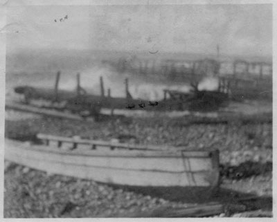
- View of Hollyburn Wharf, foot of 17th Street. Wharf has been partially destroyed by a storm.Image is extremely faded.
- Date of Original
- 1911
- Date Of Event
- 1911
- Subject(s)
- Local identifier
- 0453.WVML
- Language of Item
- English
- Geographic Coverage
-
-
British Columbia, Canada
Latitude: 49.32529 Longitude: -123.1503 -
17th Street
Latitude: 49.3296397 Longitude: -123.1555491
-
- Copyright Statement
- Public domain.
Downloading images from this site is governed by our Guidelines for Appropriate Usage and Conditions of Use. - Reproduction Notes
- Scanned August 2011 using Epson Perfection V700 Photo at 600dpi and 100% of original image size. Alternate Versions: Lossless TIF from original scan at 600dpi and 100% of original slide. W11 x H9 cm black & white print on photo paper.
- Contact
- West Vancouver Memorial LibraryEmail:turquhart@westvanlibrary.ca
Website:
Agency street/mail address:1950 Marine Drive
West Vancouver, BC V7V 1J8
604-925-7400