Horseshoe Bay
Description
- Creator
- Unknown photographer
- Media Type
- Image
- Item Type
- Photographs
- Description
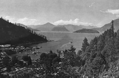
- View of Horseshoe Bay in 1960. Anvil Island and Bowyer Island can be seen in the background along with Nanaimo, Langdale, & Bowen Ferry leaving ferry landing.
- Date of Original
- 1960
- Date Of Event
- 1960
- Subject(s)
- Corporate Name(s)
- Vancouver City Archives
- Local identifier
- 0066.VCA
- Language of Item
- English
- Geographic Coverage
-
-
British Columbia, Canada
Latitude: 49.51636 Longitude: -123.30267 -
British Columbia, Canada
Latitude: 49.42465 Longitude: -123.26936 -
British Columbia, Canada
Latitude: 49.36635 Longitude: -123.26936
-
- Copyright Statement
- © West Vancouver Memorial Library
Downloading images from this site is governed by our Guidelines for Appropriate Usage and Conditions of Use. - Copyright Holder
- Vancouver City Archives
- Location of Original
- Vancouver City Archives
- Reproduction Notes
- Scanned August 2011 using Epson Perfection V700 Photo at 300dpi and 100% of original image size. Alternate Versions: Lossless TIF from original scan at 300dpi and 100% of original print. W23 x H17 cm black & white print on photo paper.VCA Number Port N616 P1076
- Contact
- West Vancouver Memorial LibraryEmail:turquhart@westvanlibrary.ca
Website:
Agency street/mail address:1950 Marine Drive
West Vancouver, BC V7V 1J8
604-925-7400