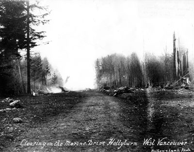
Clearing Marine Drive
Description
- Creator
- Vancouver City Archives
- Media Type
- Image
- Item Type
- Photographs
- Description
- Marine Drive looking west from Eighteenth Street during the winter. On the right, the cleared land is the corner of the proposed "Hollyburn Golf Course", which was cleared from 16th to 18th, and from Marine Drive to Haywood Ave. The post beside nearest small tree, on the right, is thought to be corner post of 18th Ave.
- Date of Original
- 1909 to 1912
- Subject(s)
- Corporate Name(s)
- Vancouver City Archives
- Local identifier
- 0019.VCA
- Language of Item
- English
- Geographic Coverage
-
-
British Columbia, Canada
Latitude: 49.33296 Longitude: -123.15265 -
Marine Drive
Latitude: 49.3387463 Longitude: -123.1975597
-
- Copyright Statement
- Public domain.
Downloading images from this site is governed by our Guidelines for Appropriate Usage and Conditions of Use. - Copyright Holder
- Vancouver City Archives
- Location of Original
- Vancouver City Archives
- Reproduction Notes
- Scanned July 2011 using Epson Perfection V700 Photo at 300dpi and 100% of original image size. Alternate Versions: Lossless TIF from original scan at 300dpi and 100% of original print. W23 x H18 cm black & white print on photo paper.VCA number: OUT.N.198 P.86
- Contact
- West Vancouver Memorial LibraryEmail:turquhart@westvanlibrary.ca
Website:
Agency street/mail address:1950 Marine Drive
West Vancouver, BC V7V 1J8
604-925-7400


